
Mobile Mapping & Navigation Systems
Warsaw University of Technology Campus, Poland

Master of Science in Geodesy and Cartography – Mobile Mapping & Navigation Systems
Warsaw University of Technology
Geodesy and Cartography
Program Overview – Mobile Mapping & Navigation Systems
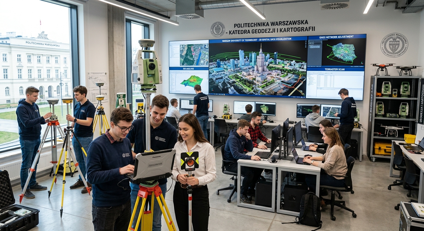
The Mobile Mapping and Navigation Systems specialization at Warsaw University of Technology is designed to equip you with advanced knowledge in collecting, processing, and analyzing spatial data for modern navigation systems. Offered by the Faculty of Geodesy and Cartography — the oldest GIS-related department in Poland, established in 1921 — this program combines cutting-edge geomatics with practical engineering skills.
Throughout the program, you will learn the principles of designing, developing, and using mobile measurement platforms and mobile mapping systems (MMS), as well as how to design location-based systems (LBS) and navigation applications using GNSS and GNSS/INS technologies. You will also gain expertise in choosing appropriate techniques for acquiring spatial data, including photogrammetry, remote sensing, and computer vision.
Launched in October 2020, this specialization is a unique course in Central and Eastern Europe, created in cooperation with industry representatives to meet the expectations of the modern geomatics labor market. You will gain comprehensive knowledge about outdoor navigation systems for self-driving cars and UAVs, as well as indoor navigation systems, preparing you to create the technologies of the future.
Key Program Highlights
- Unique specialization in Central and Eastern Europe combining mobile mapping with navigation system design
- Hands-on training with GNSS, GNSS/INS, photogrammetry, remote sensing, and computer vision technologies
- Industry-aligned curriculum developed in cooperation with geomatics sector professionals
- Comprehensive coverage of both outdoor (autonomous vehicles, UAVs) and indoor navigation systems
Curriculum & Modules
The 90 ECTS curriculum spans three semesters and is structured to build your expertise progressively from foundational geomatics concepts to advanced mobile mapping and navigation applications. Each module combines theoretical instruction with practical laboratory work, ensuring you develop both analytical and hands-on engineering skills.
GNSS and Satellite Navigation Systems
15 ECTSCovers the principles of Global Navigation Satellite Systems including GPS, GLONASS, Galileo, and BeiDou. You will learn signal processing, positioning algorithms, and the design of GNSS-based navigation applications.
Mobile Mapping Systems (MMS)
15 ECTSFocuses on the design, development, and operation of mobile measurement platforms including mobile laser scanning (MLS) systems. You will work with real-world MMS data acquisition and processing workflows.
Photogrammetry and Computer Vision
15 ECTSExplores techniques for acquiring and processing spatial data from imagery, including structure from motion, dense matching, and 3D reconstruction for mapping and navigation purposes.
Remote Sensing and Spatial Data Analysis
15 ECTSCovers advanced remote sensing methods and geospatial data analysis techniques, including LiDAR data processing, multispectral analysis, and integration of multi-source spatial datasets.
Integrated Navigation and Sensor Fusion
15 ECTSTeaches the integration and processing of data from multiple sensors (GNSS, INS, cameras, LiDAR) for navigation applications, including Kalman filtering and multi-sensor data fusion techniques.
Master's Thesis and Research Project
15 ECTSAn independent research project in which you apply your accumulated knowledge to solve a real-world problem in mobile mapping or navigation systems, culminating in a written thesis and oral defense.
Elective Modules
Admission Requirements
Admission to the Mobile Mapping and Navigation Systems specialization is competitive and open to international students holding a relevant bachelor's degree. All applications are processed through Uni4Edu, which guides you through every step of the admissions process.
Academic Requirements
- Bachelor's DegreeA completed bachelor's degree in geodesy, cartography, geoinformatics, surveying engineering, or a closely related technical field is required.
- Academic TranscriptsOfficial transcript of records showing your grades and completed coursework, used to evaluate your academic preparation.
- Relevant BackgroundThe bachelor's degree must be in a field closely related to the M.Sc. program you are applying for.
- Diploma StatusThe diploma should be final. Temporary graduation certificates or provisional diplomas may only be accepted during the initial entry documents phase.
- Motivation and FitA strong motivation letter demonstrating your interest in mobile mapping, navigation systems, and geospatial technologies.
Language Requirements
- IELTSMinimum overall band score of 6.0 (or equivalent). Contact Uni4Edu for current requirements.
- TOEFL iBTMinimum score of 87 (or equivalent). Contact Uni4Edu for current requirements.
- Alternative ProofA degree completed in English or a certificate from a recognized English proficiency test may be accepted.
Required Documents
Application Deadlines
For personalized admission guidance, document verification, and application support, please contact Uni4Edu
Scholarships & Funding
Several scholarship opportunities are available for international students pursuing the Mobile Mapping and Navigation Systems program at Warsaw University of Technology. Uni4Edu can help you identify and apply for the funding options best suited to your profile and nationality.
Polish Government Scholarship (NAWA)
Managed by the Polish National Agency for Academic Exchange (NAWA), this scholarship is available to non-EU international students pursuing master's programs at Polish universities. It covers tuition fees and provides a monthly living stipend.
For detailed tuition fee information, please contact Uni4Edu — we will guide you through the costs and available funding options for this program.
Career Prospects
Graduates of the Mobile Mapping and Navigation Systems program are well-positioned for careers in a rapidly growing sector driven by autonomous vehicles, smart cities, and geospatial intelligence. The program's industry-aligned curriculum ensures you graduate with skills that are in high demand across both public and private sectors.
Potential Career Roles
Industries and Employers
Rankings & Recognition
Warsaw University of Technology is the largest and highest-ranking engineering university in Poland, with a history dating back to 1826. It consistently earns recognition in major international rankings and holds the top position among Polish technical universities in the national Perspektywy ranking.
| Subject | Ranking Body | Rank |
|---|---|---|
| Engineering and Technology | QS World University Rankings by Subject | #151-200 |
| Earth and Marine Sciences | QS World University Rankings by Subject | Contact Uni4Edu for current data |
| Electrical and Electronic Engineering | U.S. News Best Global Universities | Top 500 |
| Computer Science | Research.com | Top 400 Worldwide |
How to Apply
Applying for this program is easy with Uni4Edu. Our team will guide you through every step of the process — from document preparation to final enrolment.
Contact Uni4Edu
Reach out to our team via email or phone. We will assess your profile and confirm your eligibility for this program.
Prepare Your Documents
Our advisors will provide you with a personalised checklist of required documents and help you prepare your application package.
Submit Your Application
Uni4Edu will submit your application on your behalf and keep you updated on its progress throughout the review period.
Receive Your Offer
Once accepted, we will help you understand your offer, arrange visa support if needed, and guide you through the enrolment process.
Similar Programmes


Master's & Postgraduate
36 months
Geography and Psychology MA (Hons)

University of Dundee, Dundee City, United Kingdom
Earliest Intake
July 2026
Gross Tuition
22500 £


Bachelor's Degree
48 months
Geography (BS)
University Of Arizona, Tucson, United States
Earliest Intake
May 2026
Gross Tuition
39958 $

Bachelor's Degree
48 months
Geosciences (BS)
University Of Arizona, Tucson, United States
Earliest Intake
January 2027
Gross Tuition
39958 $


Bachelor's Degree
36 months
Geography
University of Marburg (Philipps-Universität Marburg), Marburg an der Lahn, Germany
Earliest Intake
June 2026
Gross Tuition
900 €


Bachelor's Degree
36 months
Geography
University of Frankfurt (Goethe University Frankfurt), Frankfurt am Main, Germany
Earliest Intake
November 2026
Gross Tuition
700 €
Uni4Edu AI Assistant
